I am one of those people who see no reason to walk, jog, or run if there is a working bicycle available. We had 5 days in Estes Park , with friends, in condos only three miles from one of the entrances to Rocky Mountain National Park. And I have a Lifetime Senior Pass to National Parks. The weather was predicted to be perfect. However, a quick look at Google Maps indicated that there were no roads in the Park or even within three miles of our condo that they considered bicycle friendly. A closer look using street view convinced me that they were right.
So I packed my Merrells instead. Purchased over 10 years years ago from a bargain table at REI. Used mostly for cold weather, they did spend at least a mile on The Appalachian Trail and made it at least halfway up Half Dome. I am not a hiker. But I have logged 1600 bicycle miles so far this year, so I should be fine, right? Right.
The rest of the guys in our group chose to go on a three hour Jeep ride through the Park on Wednesday that promised to take you places that are otherwise inaccessible. That did not sound like fun to me, so that became hike day. Bonnie found an article on waterfalls along hiking trails in the Park. From that list, I chose to start at Glacier Gorge Trailhead for the hike to Alberta Falls, a round trip of 1.8 miles. It was rated "easy". I have second thoughts on my choice that I will include in the after thoughts.
Glacier Gorge Trailhead

The bulletin board at the trailhead shows that we are at 9240 feet and that Alberta Falls is at 9400 feet, an increase of 160 feet or 16 floors if there were stairs. The total gain is 210 feet.

And I am off. It was a beautiful day.

The first signpost. The trails are marked very well.
What follows are a lot of pictures with little comment. Feel free to hold down the "pg dwn" key.

Easy going so far.

Aspen!

A little steeper.


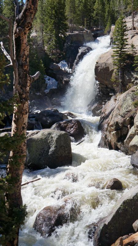
First sight of the water, although I could hear it long before.


There are better pictures of these falls, but this is as close as I am willing to go.

Returning.


The return is not all downhill!


Made it back. It warmed up enough that I tied the sweatshirt around my waist. The wind had picked up so much that that I had to stand on it to take a celebratory selfie.
My fitbit showed that I had climbed 25 floors, probably due to the little bit of rise on the way down. I suffered no ill effects until the next day when two muscles on the outside front of my lower legs reported that bicycling did not prepare them for this. I will take that into consideration next time.
Afterthoughts.
We had a lot of fun with our friends in Estes Park. Mostly eating and talking. Everyone else had been to Estes Park previously including one couple who had their wedding at the famous Stanley Hotel. Bonnie and I drove around the Park ourselves as far as Rainbow Curve. Lots of Aspen, but no Elk. I ate trout 6 times including twice for breakfast. But the highlight for me was this little hike.
Do not fear the Park and Ride. My first concern was when an electric sign informed me that the lots were full at Glacier Gorge and Bear Lake and that I would have to park and use the shuttle. At 9:00 AM! It appears that Aspen and Elk are a great attraction at this time of year. Although I had to watch one bus leave without me, they run every 15 minutes and the parking lot was indeed full. Actually overfull if you count the drivers idling while waiting for a spot. The serious hikers get there early and stay a long time.
My route choice. It was a good choice based on the information I had. I learned too late that the Park and Ride route also stops at Bear Lake trailhead and Bierstadt trailhead. A better choice for me would have been to start at Bear Lake, hike to Alberta Falls and then return to catch the shuttle at Glacier Gorge. It would have added only 0.7 miles to my route and allowed me to see a little more of the Park. Next time.
Here is a map of the Park that will show what a pitiful portion of the Park we actually saw. For my trip, I entered at Beaver Meadow and took Bear Lake Road to the Park and Ride. When Bonnie and I went, we entered at Fall River and followed Route 34 to Rainbow Curve. To actually find these locations you will need to zoom in. A lot.
So I packed my Merrells instead. Purchased over 10 years years ago from a bargain table at REI. Used mostly for cold weather, they did spend at least a mile on The Appalachian Trail and made it at least halfway up Half Dome. I am not a hiker. But I have logged 1600 bicycle miles so far this year, so I should be fine, right? Right.
The rest of the guys in our group chose to go on a three hour Jeep ride through the Park on Wednesday that promised to take you places that are otherwise inaccessible. That did not sound like fun to me, so that became hike day. Bonnie found an article on waterfalls along hiking trails in the Park. From that list, I chose to start at Glacier Gorge Trailhead for the hike to Alberta Falls, a round trip of 1.8 miles. It was rated "easy". I have second thoughts on my choice that I will include in the after thoughts.

The bulletin board at the trailhead shows that we are at 9240 feet and that Alberta Falls is at 9400 feet, an increase of 160 feet or 16 floors if there were stairs. The total gain is 210 feet.

And I am off. It was a beautiful day.

The first signpost. The trails are marked very well.
What follows are a lot of pictures with little comment. Feel free to hold down the "pg dwn" key.

Easy going so far.

Aspen!

A little steeper.


First sight of the water, although I could hear it long before.


There are better pictures of these falls, but this is as close as I am willing to go.

Returning.


The return is not all downhill!


Made it back. It warmed up enough that I tied the sweatshirt around my waist. The wind had picked up so much that that I had to stand on it to take a celebratory selfie.
My fitbit showed that I had climbed 25 floors, probably due to the little bit of rise on the way down. I suffered no ill effects until the next day when two muscles on the outside front of my lower legs reported that bicycling did not prepare them for this. I will take that into consideration next time.
Afterthoughts.
We had a lot of fun with our friends in Estes Park. Mostly eating and talking. Everyone else had been to Estes Park previously including one couple who had their wedding at the famous Stanley Hotel. Bonnie and I drove around the Park ourselves as far as Rainbow Curve. Lots of Aspen, but no Elk. I ate trout 6 times including twice for breakfast. But the highlight for me was this little hike.
Do not fear the Park and Ride. My first concern was when an electric sign informed me that the lots were full at Glacier Gorge and Bear Lake and that I would have to park and use the shuttle. At 9:00 AM! It appears that Aspen and Elk are a great attraction at this time of year. Although I had to watch one bus leave without me, they run every 15 minutes and the parking lot was indeed full. Actually overfull if you count the drivers idling while waiting for a spot. The serious hikers get there early and stay a long time.
My route choice. It was a good choice based on the information I had. I learned too late that the Park and Ride route also stops at Bear Lake trailhead and Bierstadt trailhead. A better choice for me would have been to start at Bear Lake, hike to Alberta Falls and then return to catch the shuttle at Glacier Gorge. It would have added only 0.7 miles to my route and allowed me to see a little more of the Park. Next time.
Here is a map of the Park that will show what a pitiful portion of the Park we actually saw. For my trip, I entered at Beaver Meadow and took Bear Lake Road to the Park and Ride. When Bonnie and I went, we entered at Fall River and followed Route 34 to Rainbow Curve. To actually find these locations you will need to zoom in. A lot.
Comments
Post a Comment